
Portolan Atlas
Battista Agnese, Portolan Atlas, Venice, ca. 1540
If you like to travel or you are a sailor - take these atlas, which will guide you through the ruffled waters of the seas and oceans. Enjoy the knowledge and hand precision of the most known cartographer - after all, he did not have these tools and devices, now so obvious.
Limited Edition: 295 copies
SOLD OUT


Battista Agnese, Portolan Atlas, Venice, ca. 1540
Maps were used, among others, as training tools for services–usually state services–responsible for combating pirates. Accordingly, they were quite common, useful and sought-after. The popularity of nautical charts is also explained by the ubiquity of the sea in Venetian art, literature and daily life. Demand for beautiful, colourful and handwritten, elegant atlases was high. Venice increasingly often became a destination for wealthy foreigners, who arrived not only to do business, but also learned to appreciate the art and renaissance culture of the city.
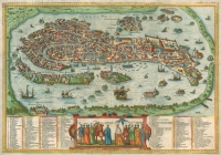 Antique map of Venice (Venezia) by Braun and Hogenberg
more >>
In the 16th century the port of Venice underwent rapid development despite numerous external obstacles such as the expansion of the Ottoman Empire and loss of monopoly in trade with Alexandria, as well as the increasingly common resignation from lending state-owned ships to private merchants. Despite these difficulties, the city still remained the pearl of Europe. It attracted numerous foreign engineers, researchers, scientists and artists. Among them were also cartographers. The demand for their services grew along with advances in science, trade, sailing, voyages to faraway lands and new discoveries – i.e. new sea routes. These became increasingly important for safe and reliable travel, fast transportation of goods and services. Additionally, from the middle of the 15th century the Republic of Venice founded numerous institutions that increasingly often used maps to enforce the important issue of state borders. Maps were needed to determine the conditions of agreements with neighbours and enemies. Drawn up and signed by the interested parties, they remained permanent and precise documents of national importance. No wonder that the demand for the work of cartographers and their products, though often very expensive, commanded respect and recognition not only from the courts of contemporary noblemen, but also sailors, burghers and merchants.
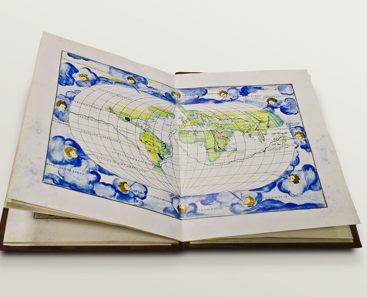
 Map of the World
more >>
In this context it may seem strange that no state-owned workshop manufacturing nautical charts was ever founded in Venice and no system of private workshops of such type under was ever established. Nevertheless, considering the number of created maps, a host of cartographers must have operated in the city. What is interesting is that their activity never evolved in to a family business model which was very popular in other Mediterranean countries (this somewhat resembles that later model of Gerard Mercator’s workshop in Duisburg).
The typical clients of cartographers were city merchants who no longer embarked on voyages, but still wanted to know the trade routes used to transport their goods. It is worth remembering that these maps were used as training tools for services, usually state services responsible for combating pirates. Accordingly, they were quite common, useful and sought-after. The popularity of nautical charts is also explained by the ubiquity of the sea in Venetian art, literature and daily life. Demand for beautiful, colourful and handwritten, elegant atlases was high. Venice increasingly often became a destination for wealthy foreigners, who arrived not only to do business, but also learned to appreciate the art and renaissance culture of the city.
The most talented and famous foreign cartographer at the time was Battista Agnese. He came from Genoa, a fact he always emphasized when signing his maps, but it is in Venice where he started and continued his long career. His personality and work came to dominate the art and science of map making in the 16th century. Not much is known about his life, all we know is information derived by analysing his works.
Researchres focused on Batista Agnese...
Henry Harrisse (1855–1910) attributed 39 atlases to Agnese created throughout 1536-64. Prof. Ingrid Kretschmer (1939–2011) increased this tally to do 54 and deduced that his career as an artist started in 1527 based on a reference regarding an atlas created that year. Anibale Carracci (1560–1609) attributed to Agnese a map bearing the inscription ”Baptista Januensis f. Venetiis MCCCCCXIV [F] Julii“, which allegedly evidences that Agnese’s career started in 1514. There were reservations that in this situation we are dealing with an unexplained, long break between the first known map and first atlas. Carracci pointed out, however, that many of Agnese’s surviving works were not dated and at the beginning of his career the artist may not have had a big workshop and only manufactured maps on a limited scale. Hermann Wagner (1840-1929) undertook to analyse Battista Agnese’s work in detail, however, he fails to mention the first map at all, indicating as Agnese’s first work the atlas dated 1536. He does admit, however, that some undated maps could have been created earlier. Gerard Roe Crone (1894–1982) contested the claim that Agnese was the author of the map from 1514, as this would mean that he worked 50 years straight. Among the studies and guesses, this date was confirmed by the Italian geographer prof. Roberto Almagia (1884–1962), who based his theory on the naming convention of important and key fragments of the shoreline and geographic places and cities. He explained the cartographer’s 50-year career with the possibility that further maps and atlases were published by heirs and new owners of the publishing workshop after Agnese’s death. Hermann Wagner counted a total of 71 Agnese’s atlases. He rejected attempts to classify them by folio size and their number in particular compilations, he also resigned from a chronological division, as many works were not dated. The criterion he adopted, was the geographical elements of atlases, thereby dividing many works based on their natural development with advances in exploring the world. This is not a fully satisfactory solution, as Agnese sometimes came back to geographical elements abandoned earlier - he modified and modernized them. Wagner’s division was based on the emergence of two elements in Agnese’s works: the Baja California Peninsula and the new shoreline of Scotland (it was no longer separated from England). As a result of this division, he distinguished three large groups:
type 1. pre-Californian (from ca. 1535 to 1541);
type 2. post-Californian (from ca. 1542 to 1552);
type 3. post-Californian with a new map of Scotland (from ca. 1552 to 1564).
Standard of Batista Agnese Atlases
 Zodiacal calendar
more >>
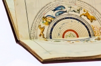
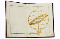 Armillary sphere
more >>
He assigned sub-groups to these groups based on varying geographical features. Nearly a third of the atlases contained the same sequence of maps and this way we can distinguish a standard Battiste Agnese atlas. The first leaf contained a richly ornamented scrollwork (according to Wikipedia an element of ornamentation using a spiral) with an oval element in the middle – empty or containing the coat-of-arms of the person who commissioned the atlas or bought the compilation. Next, comes the armillary sphere (spherical astrolabe), a zodiacal calendar (presenting the Aristotelian-Ptolemaic Universe) and a Sun declination table. These are followed by three nautical charts of oceans, comprising a full nautical chart of the world, next come six maps of the Mediterranean area and a world map projected onto an oval with parallels in equal distance, showing the route of Magellan’s voyage (characteristic element of Agnese’s works).
Later maps and unique copies
In 1542 the southern hemisphere was added, usually without latitude angles, nor names of places. From 1545 atlases were supplied not only with nautical charts of Italy and the Adriatic Sea, but also a series of portolan-styled land maps. The latter were not given detailed names of places, but include details from areas deep in land (usually completely green or yellow), and a wind system characteristic of nautical charts. The presented countries are: Italy, Dalmatia, Scandinavia, the Holy Land, Russia, the Mongol Empire and Spain, as well as the regions of Piedmont and Liguria, but without a wind system. This compilation was sometimes supplemented with historical maps presenting the world known to Ptolemy, later with nautical charts and land maps of the main island of the Mediterranean area – Cyprus, Crete, Lesbos, Chios, Rhodes, Malta and Corse – and the map of the Peloponnesian Peninsula. The maps of the British Isles, Tuscany, northern Egypt and France are typical land maps, just as the map of Africa and various areas of the New World.
There are maps that were produced only once, e.g. maps of the northern and southern hemisphere in a polar projection in the atlas dated 1 July 1544 and the land map of Italy in the Bergamo atlas that was made based on another prototype than the nautical charts and land maps of Italy and Dalmatia in the other atlases. And finally there are also unique copies for important persons, where entire folios are covered by decorative illustrations, e.g. Atlas supporting the world (in the atlas belonging to Charles V), a portrait of a young man receiving the globe from God (in the atlas gifted by Charles V to his son, Philippe II) and two mythological scenes, as well as an interesting illustration presenting two Atlases – one holding the globe, the other measuring it (work of an unknown artist, inspired by Italian mannerism). According to Wagner, Battista Agnese drew from many sources to create his works. It is even considered that he borrowed elements, adding little from himself. Without a doubt, however, the cartographer-artist Battista Agnese gained international recognition. His atlases were found in Germany, England and all of Europe. Often in castle libraries far away from the sea.
 Stamp of the Konigsberg State and University Library
more >>
One such an example is the copy discussed here from the collection of the State and University Library in Konigsberg which, as Heinrich von Hesler’s Apocalypse and many other books from Konigsberg, found their way to Toruń through Słobity and Karwiny and later through the repository of books in Pasłęk. In Kongisberg it was kept not in the collection of cartographic collection, but the collection of manuscripts and was given the reference number 2445. The reference of this atlas indicates that it was added to the collection of the Konigsberg library at the end of the 19th century.
Facsimile Edition
 Portolan Atlas
more >>
The presented copy bears of the physical features of the original:
Made on pergamenata – the modern parchment. The print was ennobled with hand-gilding that perfectly illustrates the mirror effect. The binding, as in the original, is made from boards covered in finely fleshed, blind-stamped and additionally gilded leather.
This work is the most beautiful artefact and document of European culture of the Renaissance.
Specification:
Battista Agnese, Portolan Atlas, Venice, ca. 1540
Dimensions: 190 x 260 x 20 mm
Number of leaves:15, of which many hand-gilded
Paper: pergamenata 115 g/cm2
Binding: boards dressed in goatskin, stampingsand gildings, gold-punched atlas block, (binding - in this case packing- could be different from what you see on the pictures)
Packaging: wooden case with a stamped gold inscription,padded with jute ;dimensions: 290 x 410 x 35 mm
Limited print-run: 295 copies. Available: less than 10 copies
Price: 1300€

