
Mercator Atlas
Gerardus Mercator, Atlas sive cosmographica, Duisburg, 1595
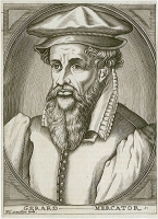
Gerardus Mercator - (1512 - 1594) was a cartographer, philosopher and mathematician. He is best known for his work in cartography, particular the world map of 1569 based on a new projectionwhich represented sailing courses of constant bearing as straight lines. He was the first to use the term Atlas for a collection of maps.
Limited Edition: 294 copies
Available: less than 4 copies


Gerardus Mercator, Atlas sive cosmographica, Duisburg, 1595
Gerardus Mercator and cartography.
 Gerardus Mercator
more >>
The 16th century was marked by a revolution in European and world cartography. In this century, one of the leading and most famous cartographers of all time, Gerhard Kremer, called Gerardus Mercator (1512-1594), started his cartographic and publishing activity.
He was born on 5 March 1512 in Rupelmonde, near Antwerp in East Flanders in modern day Belgium.On 29 August 1530 he was accepted to the Louvain University where he studied philosophy until 1532.This marked the beginning of the first period of his exploits in cartography.During his studies he encountered the teachings of Rainer Gemmy Frisius which deepened his interest in mathematics, geometry and astronomy. At that time he started building his first astronomical and measurement instruments.
Due to financial reasons, he also worked as a geometer making measurements and plans of land estates of, among others, the bishops of Valencia and Arras. All these endeavours started to provide considerable income to Mercator. In 1537 he published his first map, it presented the Holy Land – Terrae sanctae description (…). Unfortunately, the map did not survive to the present day. The keen interest of the cartographer in scientific cartography is evidenced by the map of Earth, Orbis imago (…), made on a double heart-shaped projection.
In his comment to this map, he announced publishing a monumental map of Europe, that he had started working on earlier. Around 1540 Mercator published his first topographic map showing Flanders in 9 sheets in a scale of approximately 1:166 000 – Vlaenderen. Exactissima (Flandriae descriptio). In the same year he wrote a manual for cartographers on applying the proper typefaces, Literarum latinarum quas italicas, cursoriasque vocant, scribendarum ratio (Antwerp 1540), e.g. introducing italics to cartography for the first time.
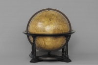 Earth Globe
more >>
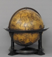 Globe of the Sky
more >>
During his stay in Louvain, in 1541, Mercator created a globe of the Earth, dedicating it to Nicolaus Perrenot von Granvelle, secret advisor to Emperor Charles V, which enjoyed much recognition and popularity. This work is the first single image of the world, created by Mercator using the latest and most up-to-date source materials. The lands of the Polish Kingdom and Grand Duchy of Lithuania were prepared based on the maps of Bernard Wapowski from 1526. Apart from the globe of the Earth, Gerardus Mercator also created a celestial globe, published in 1551. It was dedicated to Georg von Österreich, the bishop of Lüttich (Liège). It is important to emphasize that one of the copies of the celestial globe is currently in the collection of the Copernicus Library in Toruń (ref. no. 17). The globes and measurement instruments produced for Emperor Charles V brought Mercator the honourable title of “counsel to the court” which, however, he did not use.
Due to his Lutheran sympathies and later religious persecution in the Netherlands, Mercator was forced to leave Louvain and with his family moved to Duisburg in the Duchy of Cleve (currently North Rhine-Westphalia in Germany).
After moving, Gerardus Mercator finished his map of Europe – EVROPAM descripturi Primus curauimus vt Spacia meridianis (…) issued in 1554, in a scale of approximately 1:4 000 000 in fifteen folios. It was supplemented based of numerous travels of Englishmen to Russia using the so-called Northern Sea Route and published for a second time in 1572.
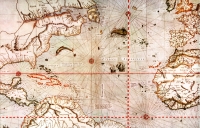 Nautical Chart of the World
more >>
Merctor’s life work was, however, a nautical chart of the world composed of eighteen sheets - Nova et aucta orbis terrae descriptio ad usum navigantium emendate accomodata, published in 1569 in a scale of approximately 1: 21 000 000 at the equator. It was dedicated to Prince Wilhelm von Kleve. This worked revolutionized sea navigation as it was made as the famous cylindrical map projection, which came to be known as the Mercator projection.
Since 1564 Mercator attempted to realize his great scientific plan, involving the publishing of a full and more perfect cosmography. In 1578 he issued a new version of Ptolemy’s Geography.
The second half of the 16th century was marked by a rapid development of atlas cartography. Gerardus Mercator was inducted to the pantheon of famous publishers of map collections among such as persons as Abraham Ortelius and Gerard de Jode, both from Antwerp.
 Atlas
Atlas
more >>
Mercator called his maps, collected and organized into one whole, the “Atlas”. He by no means meant the titan Atlas who, punished by Zeus, was to bear the heavenly vault on his shoulders. Mercator wanted to pay homage to Atlas, the mythical King of Mauretania. He was considered a philosopher, mathematician and astronomer, and the creation of the first celestial globe is attributed to this very Atlas. In the preface to his work, Mercator clearly stated which Atlas he meant. The first edition of his atlas was published in 1585, although it was not yet complete. The last part was published only after his death in 1595. Works on the atlas became protracted as Mercator, seeking to make the “perfect work” tried to collect as much up to date source materials as possible. The importance of this atlas is best attested by the huge number of its editions and reissues.
Gerardus Mercator is the originator of the name of a systematized collection of maps – the atlas. The first systematic collections of maps had been already published by Abraham Ortelius (1570) and Gerard de Jode (1578), yet it was Mercator’s new project entitled Atlas sive cosmographicae meditationes de fabrica mundi et fabricati figura, that was to surpass the achievements of earlier cartographers.
Following the example of his prior works, among others, the great map of Europe (1554 and 1572) and the world (1569), to make his new maps, Mercator tried to collect the latest source materials. Until then Ortelius only standardized the format of maps; de Jode had already introduced some supplements, creating compilation maps, whereas Mercator in his atlas included new maps, based on a range of latest source materials. These were carefully selected and, as far as possible at the time, studied critically.
The team working on the new work included Mercator’s three sons and several etchers. The first part of Mercator’s work from 1585 contains 51 maps of Gaul (France), the Netherlands and Germania. The map of Poland was included in Germania. In 1589 the next part was published. It comprised 22 maps covering Italy, Greece and the Balkans.
Gerardus Mercator died in 1594, failing to see the publication of the complete atlas which, supplemented with additional maps was published in 1595 by his son, Rumold. The complete edition of the atlas included Mercator’s treatise on the creation of the world. The maps of particular countries and continents were provided with geographical descriptions. Some copies of the new edition only featured maps from the third part. These were to serve as supplements to atlases issued earlier, in 1585 and 1589. In 1602 the next full edition of the atlas from 1595 was printed with small typographic changes introduced to pages containing geographical descriptions. In 1604 Jodocus Hondius (1563-1612) purchased the copperplates used to make the atlas from Mercator’s heirs. Next, he expanded on the contents of the atlas and started publishing it in 1607.
Toruń copy of Gerardus Mercator’s Atlas from 1595
The Toruń copy of Mercator’s atlas of 1595, entitled ATLAS SIVE COSMOGRAPHICAE MEDITATIONES DE FABRICA MVNDI ET FABRICATI FIGVRA is composed of two parts: ATLANTIS Pars altera, GEOGRAPHIA NOVA TOTIVS MVNDI and ITALIAE, SCLAVONIAE, GRAECIAE, geographice Per Gerardum Mercatorem Illustrissimi Ducis Juliae, Cliuiae, etc. Cosmographum Duysburgi edita. It was made using a copperplate on vat paper and hand-coloured. The first of them is the final supplement to the publication started by Mercator in 1585. The second one was completed and published in 1589 as an independent collection of maps of the countries of Southern Europe.
The first part was dedicated by Rumold Mercator to Elisabeth I (1533-1603) (leaf “c2”) on 1 April 1595. It comprises an extensive biography of the great cartographer (leaf “*-*2”), a eulogy, and next letters from Reihardus Solenander and Iacobus Sinstedius. Further on is the introduction to the atlas (leaf “aI” p. 1.) and the description of the creation of the world (leaf “a2-d4” p.3-32). The treatise on the creation of the world was published by Mercator in 1594 as an independent work.
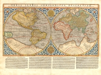 Map of the World
more >>
In the next part, the publisher included the first maps with descriptions of presented lands. The atlas includes planiglobes presenting the eastern and western hemispheres and maps of the following continents: Europe (leaf “B”), Africa (leaf “C”) and Asia (leaf “D”). As compared to the full publication from 1595, this edition lacks the map of America (leaf “E”), which should follow the map of Asia. The maps of continents were made based on a huge nautical chart of the world from 1569.
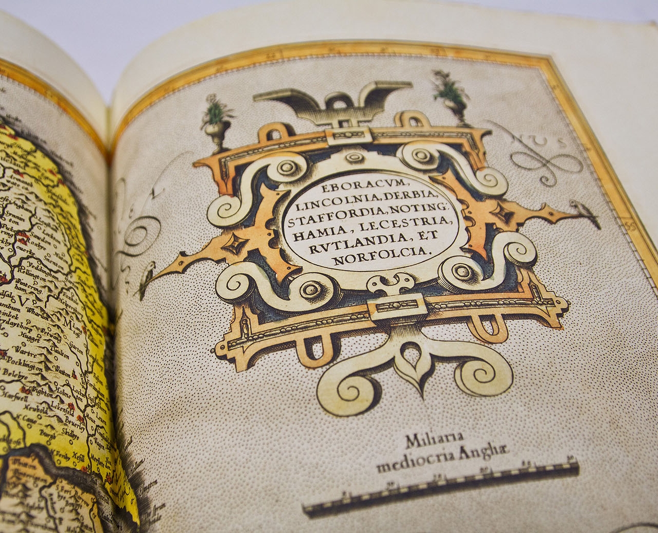
Next, the atlas features 29 maps of the Arctic and the countries of Northern and Eastern Europe (leaf “I-XXIX”). The part entitled Atlantis Pars altera also includes the maps of lands owned by Poland and its neighbouring countries: Prussia (leaf “XXIV”), Livonia (leaf “XXV”), Russia cum confinijs (leaf “XXVI”), Lithuania (leaf “XXVII”), Taurica Chersonesus (leaf “XXIX”).
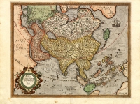 Asia
Asia
more >>
In the independent part, Atlantis Pars altera, and full editions of Mercator’s atlas published in 1595, the maps of the countries of Northern and Eastern Europe are followed by indices for the maps of the British Isles (4 pages) and the maps of Scandinavian countries (4 pages). These, however, are missing in the Toruń copy. For example, in the complete copy of the Library of the US Congress, these indices are featured after the map of the Scandinavian Peninsula, but before the description of Denmark (leaf “XXa”).
Next, the full editions of the Mercator atlas published in 1595 contain three parts published initially in 1585. These are: Galliae tabule geographicae (…) (leaf “† ij-**j” (16 maps), Belgii Inferioris Geographicae tabule (…) (leaf “†2-†ij”) (9 maps) and Germaniae tabule geographicae (…) (leaf “† † 2-† † † 3”) (26 maps). Unfortunately, the Toruń copy does include these parts, which sets it apart from other surviving copies. In the part dedicated to Germania, there is a map of the Brandenburg March and Pomerania Marca Brandenburgensis [et] Pomerania (leaf “S”) in a scale of approximately 1:900 000 and Poland and Silesia Polonia Et Silesia (leaf “Z”) in a scale of approximately 1:1 600 000. Germania was included as a geographical term (by authority of Ptolemy), not a political one, i.e. as the area ranging to the line of the Vistula river.
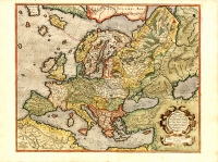 Map of Europe
more >>
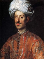 Ferdinando II de' Medici, Grand Duke of Tuscany
more >>
The second part of the Toruń copy, containing the maps of Southern Europe was dedicated to cardinal Ferdinand II de’ Medici, the Grand Duke of Tuscany. It contains a total of 22 maps (leaf “1-22”): 15 maps of the countries of Italy, three maps of Styria, the Balkan countries and Danube Duchies and four maps of Greece, its regions and islands. The folios are numbered using Arabian numerals. Leaves “14” and “22” are particularly interesting. The first of them includes two separate maps presenting Corse and Sardinia. The second one presents Crete, along with lesser sheets presenting 6 Greek islands. Pages containing the description of the presented area show small typographical differences as compared to the independent edition of this part from 1589. These are small changes to the text and decorations, which allows for dating maps that were in free circulation. The maps are followed by an index of names used in the general maps of Italy and Greece and an index of the 22 maps. Indices in the Toruń copy (leaf “a- -“) are numbered differently than in the full issue (folio „††-†††”). The next four pages contain an index of names used in the maps of Norway and Sweden, while the next four the index of names from the maps of the British Isles which further distinguishes the Toruń copy from other editions published in 1585.
Lands of the Polish–Lithuanian Commonwealth on the Atlas Maps of Mercator
Gerardus Mercator intended for his maps to be complete, nearly perfect. That is why they are not directly retraced from the works of earlier cartographer or publishers, as practiced by Abraham Ortelius, but made from scratch. Consequently, Mercator could not visit all the presented countries, so for map-making he used the latest available sources, which were often contradictory, that is why we can find names of some cities duplicated or even triplicated. Nearly all his maps are compilations. This particularly applies to the lands of the former Polish–Lithuanian Commonwealth. Among them, the atlas in question included the maps of Prussia, Livonia, Russia, Lithuania and Crimea.
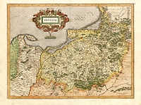 Map of Prussia
more >>
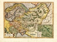
The map of Prussia was made in a scale of approximately 1:850 000, on the basis of the map of Prussia of Kaspar Henneberger from 1576 (its original 1st edition is in the Copernicus Library, ref. no. 1) and the map of the Danzig Coast by Janszoon Waghenaer from 1585. The map of Livonia in a scale of approximately 1:1 700 000 was prepared based on the materials of a Pole, Maciej Strubicz (published in 1589), from the period of the wars of Stefan Batory’s with Ivan the Terrible for Livonia and the map of Livonia by Johannes Portantius from around 1573. Just as the map of Livonia, the maps of Russia, in a scale of approximately 1:8 000 000, were made by Gerardus Mercator based on the materials of Maciej Strubicz. Of particular interest is the map of Lithuania in a scale of approximately 1:3 000 000 as it was first to fully present exclusively the Grand Duchy of Lithuania. In Lithuanian historiography it is considered as the first independent representation of these lands, with only the name of Lithuania – LITHVANIA in the title. The basic source of information used to plot it was the map of Europe from 1572, supplements were made based on the maps of: Maciej Strubicz, Wacław Grodecki, Andrzej Pograbka, Stanisław Pachołowiecki and Giacomo Gastaldi, hence the numerous duplications and even triplications. The map of Crimea in a scale of approximately 1:3 500 000 was produced by Mercator based on his own map from 1572.
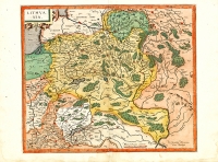 Map of Lithuania
more >>
 Map of Russia
more >>
Though not included in the Toruń copy, the map of Poland and Silesia deserves some acknowledgement. It is characterized by very clear drawings and rich contents. To make it the great cartographer used nearly all available cartographic sources. It was based on the atlas map of Poland by Gerard de Jode from 1578. Moreover, supplements were made based on the maps of: Poland by Wacław Grodecki, of Sarmatia by Andrzej Pograbko, of Europe by Gerardus Mercator, and of Poland by Giacomo Gastaldi.
It provides and interesting representation of the borderlands of: Kujawy, Masovia and Prussia based on the map of Prussia by Kaspar Heneberger of 1576; Greater Poland, Pomerania and Brandenburg based on the maps of Brandenburg by Elias Camerarius and Western Pomerania by Peter Becker called Artopöus of 1550; Greater Poland and Silesia based on the map of Silesia by Martin Helwig of 1561, Lesser Poland and Silesia based on the map of Silesia by Martin Helwig of 1561 and the map of the Duchy of Oświęcim and Zator by Stanisław Pachołowiecki of 1563. The Polonia Et Silesia map included in this facsimile edition as an appendix comes from the French edition of the Atlas published by Jodocus Hondius in 1609.
Considering all the editing details that distinguish the Toruń edition of Mercator’s atlas from 1595, we may assume that this was a supplement issued for holders of the first part from 1595, composed of the maps of Gaul, Belgium and Germania. At the time also the edition of 1589 containing maps of Southern Europe was republished. Moreover, there are also differences in maps and the layout of indices.
Specification
Gerardus Mercator, Atlas sive cosmographica, Duisburg, 1595
Dimensions: 320 x 440 x 90 mm
Number of leaves: 252
Paper: smooth, cotton paper
Binding: boards, leather, blind stamps, (binding - in this case packing- could be different from what you see on the pictures)
Packaging: slip in case – flock, leather, paper; dimensions: 325 x 455 x 95 mm Limited print-run: 294 copies Available: less than 25 copies
Price: 2130€

